

Nepal is confronting a devastating natural disaster after a massive wall of water, mud, rocks and glacial debris swept through communities along the Nepal-Tibet border and surged downstream through Himalayan river valleys on August 26, 2026. Entire settlements have been damaged, roads and bridges destroyed, hydropower infrastructure affected, and hundreds of people killed, while large numbers remain missing.
The casualty figures are still changing rapidly as rescue teams reach isolated areas, so any precise death toll should be treated as provisional. Recent reporting puts the number of confirmed deaths in the hundreds, with well over a thousand people reported missing across Nepal and Tibet. (AP News)
Early reports suggested that an earthquake might have triggered the catastrophe. Scientists now have a very different explanation. According to the U.S. Geological Survey analysis cited by Nature and The Guardian, what seismic instruments initially detected was apparently not a conventional tectonic earthquake but an enormous glacial collapse and debris flow. The collapse itself generated seismic energy equivalent to roughly a magnitude-5.2 event. (Nature)
That distinction fundamentally changes how the disaster should be understood.
This was not simply another monsoon flood. It appears to have been a cascading Himalayan disaster in which ice, rock, gravity, water, extreme terrain and possibly climate-related warming combined to produce an extraordinarily destructive chain reaction.
What Happened in the Himalayas?
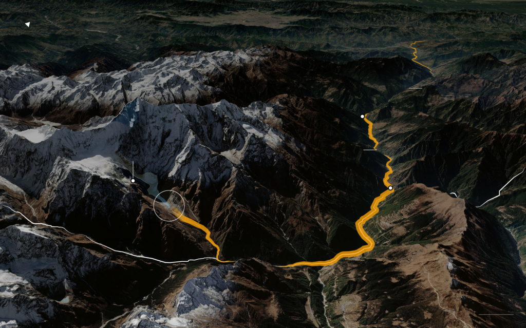
Scientists are still reconstructing the precise sequence, but satellite observations and seismic analysis point toward a huge mass of glacier ice collapsing high in the mountains near the Nepal-China border.
Preliminary analysis cited by The Guardian suggests that roughly 0.2 square kilometres of glacier ice may have collapsed vertically by about 1.2 kilometres.
Imagine the enormous energy involved.
Millions of tonnes of ice and rock descending more than a kilometre do not behave like an ordinary landslide. The collapsing mass can fragment, melt, entrain additional rock and soil, displace water and accelerate into a highly destructive debris flow.
Once this material entered the river system, it appears to have generated an enormous surge.
The result was effectively a mountain-generated tsunami moving through narrow valleys.
Water mixed with:
- glacier ice,
- boulders,
- soil,
- trees,
- sediment,
- structural debris.
That mixture can be far more destructive than ordinary floodwater because of its density and momentum.
The Disaster Became a Chain Reaction
The Nepal catastrophe illustrates what scientists call a cascading hazard.
Instead of one event producing one consequence, one physical failure triggers another:
Glacial instability
↓
Ice/rock collapse
↓
Massive avalanche and debris flow
↓
River displacement and flash flooding
↓
Additional erosion and landslides
↓
Destruction of roads, bridges and settlements
↓
Isolation of communities
↓
Difficult rescue operations
This cascading mechanism helps explain why devastation can extend far downstream from the original collapse.
The event reportedly sent destructive flooding into the Bhote Koshi and wider river system, affecting communities far removed from the initial mountain failure. (Nature)
Why Was the Flood So Destructive?
Nepal’s geography provides part of the answer.
The Himalayas contain some of the world’s greatest vertical relief. Rivers descend extremely rapidly through narrow valleys.
In flatter terrain, floodwater can spread outward and lose some energy.
In a steep Himalayan gorge, however, enormous volumes of water and debris can become channelled into a relatively narrow corridor.
The terrain effectively acts like a funnel.
That means a destructive surge can travel downstream with extraordinary velocity and force.
The same geography that gives Nepal its spectacular mountains also makes parts of the country exceptionally vulnerable to:
- landslides,
- flash floods,
- earthquakes,
- glacial collapses,
- glacial-lake outburst floods.
Climate Change Is an Important Part of the Investigation
The next question is unavoidable:
Did climate change cause the Nepal disaster?
The scientifically responsible answer is more nuanced than a simple yes or no.
Scientists cannot automatically attribute one individual glacier collapse entirely to climate change. Mountain failures can result from several interacting factors, including geology, slope geometry, accumulated stress, rainfall, ice dynamics and temperature.
However, researchers are increasingly concerned that global warming is destabilizing high-altitude mountain environments and increasing the background conditions in which catastrophic failures can occur.
N ature reports that scientists regard global warming as an increasingly important factor destabilizing high-altitude regions. (Nature)
That relationship deserves closer examination.
Himalayan Glaciers Are Retreating
As temperatures rise, glaciers lose mass.
Their ice becomes thinner.
Glaciers retreat uphill.
Previously frozen rock faces become exposed.
Meltwater penetrates fractures.
Ice that once helped support mountain slopes disappears.
All of this can alter the mechanical stability of the surrounding landscape.
Reporting on the Nepal disaster notes that Nepal has already lost a substantial portion of its glacier area over recent decades, while many smaller glaciers have disappeared altogether. (WIRED)
The consequences extend beyond sea-level rise.
In mountainous regions, glacier retreat can literally change the structural stability of the landscape.
Permafrost May Be Another Hidden Danger
High mountains contain permanently or seasonally frozen ground that can effectively act as natural cement.
When temperatures increase, this frozen material can thaw.
Rock fractures that were once stabilized by ice can become weaker.
Water can penetrate deeper into the mountain.
Rockfalls and slope failures may become more likely.
Scientists are increasingly studying this phenomenon in the Alps, Himalayas and other high mountain systems.
That means climate change can influence disasters indirectly.
It does not need to “create” the mountain collapse.
It may gradually weaken the conditions that previously kept the mountain stable.
Heavy Monsoon Rainfall Could Have Added Another Stress
Nepal was already experiencing its monsoon season.
Heavy rainfall had triggered floods and landslides in other parts of the country earlier in August, damaging homes, bridges and roads. (Kathmandu Post)
Heavy rainfall can increase mountain instability in several ways.
Water saturates soil.
It increases pore-water pressure.
It adds weight to unstable slopes.
It enters fractures.
It accelerates erosion.
When this happens simultaneously with glacier melting and unstable high-altitude terrain, several hazards can reinforce one another.
Researchers cited in recent coverage have therefore pointed to the combination of recent heat and monsoon rainfall as possible aggravating conditions, although the precise contribution of each factor to the August 26 collapse remains under investigation. (The Guardian)
The Initial “Earthquake” Explanation Was Misleading
One of the most fascinating scientific aspects of the disaster concerns the seismic signal.
Initial reports interpreted the detected event as an earthquake.
Further analysis indicated something different.
The USGS concluded that the seismic event resulted from the glacial collapse and debris flow itself, rather than an earthquake triggering the glacier failure. (The Guardian)
This matters because the causal chain changes from:
Earthquake → glacier collapse → flood
to something closer to:
Glacier/rock collapse → seismic signal + debris flow → catastrophic flood.
Scientists will continue examining the event, but this distinction substantially changes the current understanding of the disaster.
Glacial Lake Outburst Floods Remain a Wider Himalayan Threat
The catastrophe also highlights another major Himalayan danger: Glacial Lake Outburst Floods, or GLOFs.
As glaciers retreat, meltwater can accumulate behind unstable natural barriers made of ice, moraine and rock.
These lakes can become enormous.
If their natural dam fails because of:
- an avalanche,
- landslide,
- earthquake,
- glacier collapse,
- extreme rainfall,
- rapid melting,
millions of cubic metres of water can suddenly escape.
The result can be a catastrophic downstream flood.
Even where the present Nepal event is ultimately classified primarily as a glacier/rock avalanche rather than a conventional GLOF, the underlying message is similar:
A warming Himalayan cryosphere is creating new and evolving hazards.
Why Nepal Is Particularly Vulnerable
Natural hazards alone do not determine disaster severity.
A disaster becomes catastrophic when a major hazard intersects with vulnerable communities and infrastructure.
Nepal has several structural vulnerabilities.
Mountain Settlements
Many communities are located in narrow river valleys because relatively flat land is scarce.
Unfortunately, these same valleys can become channels for flash floods and debris flows.
Limited Escape Routes
Mountain roads often provide the only connection between communities.
When a bridge collapses or a landslide blocks a highway, entire settlements can become isolated.
Hydropower Infrastructure
Nepal relies heavily on its rivers for electricity generation.
Hydropower facilities therefore tend to be located in precisely the river corridors most exposed to extreme flooding.
Recent reports indicate that numerous hydropower projects were affected by the latest disaster. (The Times of India)
Difficult Rescue Geography
A rescue operation that might require an hour on flat terrain can require many hours—or helicopters—in the Himalayas.
Bad weather compounds the difficulty.
When roads and bridges disappear, helicopters may become the only practical means of reaching some locations.
Infrastructure Magnified the Human Impact
Preliminary assessments illustrate the scale of destruction.
Recent reporting describes approximately 40 kilometres of damaged road, at least 19 bridges affected or destroyed, hundreds of vehicles swept away and multiple hydropower projects impacted. (The Times of India)
This creates a secondary disaster.
Destroyed infrastructure means:
No road → delayed rescue
No bridge → isolated village
No electricity → communication failures
No telecommunications → families cannot locate relatives
Damaged water supply → disease risk
Destroyed farmland → longer-term livelihood crisis
The consequences therefore continue long after the floodwater recedes.
Why Were So Many Foreigners Affected?
The disaster occurred near an important Nepal-Tibet travel corridor used by tourists and pilgrims.
The region connects with routes associated with Mount Kailash and Lake Mansarovar, sacred destinations particularly important to Hindu, Buddhist, Jain and Bon religious traditions.
Large numbers of international visitors were therefore travelling through the region when the catastrophe occurred.
Reports indicate that foreigners—including Indian pilgrims and tourists from several other countries—are among those missing. (The Wall Street Journal)
This transforms the disaster from a Nepalese emergency into an international humanitarian crisis.
The Implications for India Are Significant
India should pay particularly close attention.
First, Indian nationals are among those affected.
Second, India shares the Himalayan ecological system with Nepal.
The processes destabilizing Nepal’s glaciers do not stop at political borders.
India’s Himalayan states—including:
- Uttarakhand,
- Himachal Pradesh,
- Sikkim,
- Arunachal Pradesh,
face related risks involving glaciers, glacial lakes, landslides and extreme precipitation.
The 2021 Chamoli disaster in Uttarakhand, where a massive rock-and-ice avalanche produced a destructive downstream flow, provides an obvious comparison. Scientists are now examining similarities between that event and the Nepal catastrophe. (The Wall Street Journal)
The lesson for India is therefore immediate.
Nepal’s disaster should be studied as a warning for the entire Himalayan region.
Climate Change Is Turning Historical Data Into a Less Reliable Guide
This may be one of the most important implications.
Engineers traditionally design bridges, dams, roads and hydropower facilities using historical assumptions about rainfall, floods and geological hazards.
But climate change can alter those assumptions.
A flood described as a “once-in-100-years” event is based on historical probability.
If temperature, rainfall intensity, glacier geometry and snowmelt patterns are changing, historical frequency may no longer accurately describe future risk.
Infrastructure therefore needs to be designed for a changing climate rather than the climate of the twentieth century.
Early Warning Systems Need to Become Much More Sophisticated
Traditional flood forecasting concentrates heavily on rainfall and river levels.
Himalayan countries increasingly need integrated monitoring of:
- glacier movement,
- glacial lakes,
- slope deformation,
- permafrost,
- seismic activity,
- satellite imagery,
- river gauges,
- rainfall,
- temperature.
Satellite radar can detect extremely small changes in ground movement.
Remote sensing can monitor glacier retreat.
Automated river sensors can identify sudden surges.
AI and machine-learning systems can combine these datasets and flag unusual patterns.
Recent research has specifically examined whether freely available satellite radar and weather information can help identify Himalayan glacial-lake and landslide risk. The results suggest such data can contribute to risk prioritization, although researchers emphasize that these systems are not yet perfect predictive tools. (arXiv)
Nepal Cannot Solve the Problem Alone
The Himalayan cryosphere stretches across national borders.
Glaciers and rivers connect:
China/Tibet → Nepal → India → Bangladesh
A hazard beginning high in one country can affect communities downstream in another.
Effective protection therefore requires regional data sharing.
Countries need mechanisms for sharing:
- glacier observations,
- rainfall forecasts,
- river levels,
- satellite analysis,
- seismic information,
- emergency alerts.
Politics cannot stop a flood at a border.
Development Planning Must Change
Nepal also faces a difficult development dilemma.
The country needs:
- roads,
- hydropower,
- tourism,
- housing,
- border infrastructure.
But constructing infrastructure in increasingly unstable mountain corridors can create enormous exposure.
Future development therefore needs stronger multi-hazard assessments.
Before approving a major road, settlement or hydropower project, planners should consider not only normal flooding but:
glacial collapse + landslide + GLOF + earthquake + extreme rainfall + cascading failure.
That represents a fundamental shift from single-hazard planning toward systemic risk planning.
Was the Disaster Preventable?
The glacial collapse itself may not have been preventable.
But the scale of human loss can potentially be reduced.
Better monitoring might provide warning.
Better hazard mapping can prevent construction in extremely vulnerable corridors.
Stronger bridges can improve resilience.
Emergency shelters can save lives.
Redundant communications can keep communities connected.
Evacuation protocols can reduce casualties.
Satellite monitoring can identify rapidly changing glacial conditions.
In disaster management, therefore, the question is rarely:
“Could humans have stopped nature?”
The more useful question is:
“Could society have been better prepared for what nature was capable of doing?”
A Warning From the Himalayas
The Nepal disaster may ultimately become an important case study in how climate change interacts with geological hazards.
Climate change is often imagined primarily through gradual phenomena:
rising temperatures,
melting glaciers,
rising seas.
But mountains demonstrate another possibility.
Slow environmental change can eventually produce sudden catastrophic failure.
A glacier may retreat gradually for decades.
A mountain slope may weaken gradually.
Permafrost may thaw gradually.
Meltwater may accumulate gradually.
Then one morning, part of the mountain collapses.
The consequences arrive in minutes.
That is what makes Himalayan climate risk particularly dangerous.
Conclusion
The devastation in Nepal appears to have resulted from an extraordinary combination of glacial collapse, rock and debris movement, extreme Himalayan topography and catastrophic downstream flooding. Current scientific analysis indicates that what was initially interpreted as an earthquake was instead a seismic signal generated by the massive collapse itself. (Nature)
Climate change cannot yet be described as the sole proven cause of this specific event. But scientists have strong reasons to be concerned that rising temperatures, glacier retreat, increased melting and destabilization of high-altitude terrain are making disasters of this kind increasingly dangerous. (The Guardian)
Nepal’s tragedy therefore carries a message far beyond Nepal.
It is a warning for the entire Himalayan belt—from Pakistan and India through Nepal and Bhutan to Tibet—that the mountains themselves are changing.
Governments will need to invest far more aggressively in glacier monitoring, satellite surveillance, early-warning systems, climate-resilient infrastructure, hazard mapping and cross-border emergency coordination.
The Himalayas have always been geologically young, steep and unstable.
Climate change is adding another layer of uncertainty to that already fragile environment.
And the most important lesson from Nepal may ultimately be this:
The next Himalayan disaster may begin far above any town or village, in a place where almost nobody lives—but the consequences can travel hundreds of kilometres downstream.
That means protecting Himalayan communities increasingly requires watching not only the weather above them, but the mountains themselves. (Frontiers)
I can monitor the Nepal disaster and let you know if scientists confirm the precise trigger or there are major updates to the rescue effort.
